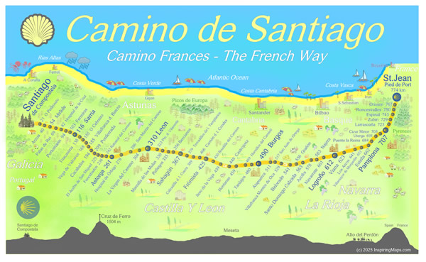
Welcome to the Camino de Santiago big picture map!
I find it useful to have an overview of an entire hike, however long it is. I also have a love for map creation too! For these reason I have created a unique one page PDF Camino Frances map that can help you plan your Camino hiking days!
What is the Camino Frances?

The Camino Frances runs across the north of Spain starting in the French mountain town of St Jean Pied de Port. The first day for many pilgrims involves a long hike over the Pyrenees which can be a real shock to the system, particularly as many pilgrims are not prepared for the physical challenge!
What is a Camino Frances Big Picture Camino map?
It is a single page PDF document that has the distances between villages and towns marked out, from St Jean Pied de Port in France. I have deliberately left off the individual town to town distances because it’s easy to work out, and your brain gets a little exercise too! 😉
There are also a number of useful links and some general information. I have also created a map for the Via de la Plata Camino too.
The map can be viewed on any laptop or device, but is actually best suited for a mobile/cell phones, making it easy to access while you are on the Camino! There are also links to some useful travel sites too.
We sell products through our online partner Redbubble, who will create and ship your product worldwide and in your own currency.
Link to our REDBUBBLE store >
Latest on the Camino de Santiago
2021 to be a record year for the Way of St James
The Camino de Santiago is gearing up for a record year in 2021. This is because 2021 is a Holy Year. Holy Years are always the most busiest, with the last one being in 2010. Whenever St. James’s Day (25 July) falls on a Sunday, the cathedral declares a Holy or Jubilee Year. Depending on leap years, Holy Years occur in 5-, 6-, and 11-year intervals. The most recent were 1982, 1993, 1999, 2004, and 2010.
The next will be 2021, 2027, and 2032. Holy years are always very crowded so you can expect there to be even more of a bed rush! A bed rush is when the number of pilgrims exceed the number of beds. Along the Camino there are a number of towns that seem to struggle with excessive numbers of pilgrims.

How to avoid the Camino Frances crowds?
Picking your month is definitely a good idea if you want to avoid the massive crowds on the Camino Frances. The busiest months tend to be June, July and August. The shoulder months of May and September are also becoming very busy too, particularly when Easter week falls in May. Many Spanish people will walk from Sarria to Santiago during Easter.


1 thought on “Camino de Santiago Big Picture Map”
Comments are closed.